Yet more stuff
If there is a heaven set aside just for motorcyclists it’s going to look a lot like New Zealand. The roads here seem made for bike travel with lots of elevation change, curves including broad sweepers and mountain switchbacks with spectacular scenery no matter where ones gaze might fall. The only difficulty with NZ is keeping ones eyes on the road instead of the scenery but then again if it does turn out to be heaven I’m sure there’ll be provisions made for that.
In every little road side café even out in the middle of nowhere the variety of food and desserts is astounding. If I stay much longer I will weigh 300 pounds and won’t be able to fit back on the bike.
On Saturday morning 14th, we left TeAnau and headed south again to make the large circle back around to Frankton and then to head north to the west coast. It seems rather odd to see signs directing us to the west coast while the highway is running southeast. For the first hour or two we pass tour buses headed the other way obviously coming from Queenstown going up to Milford Sound. While the buses are quite nicely appointed for tourists it would seem to me to be very much like watching the whole experience as a movie as opposed to what we are doing, which is participating in the movie.
We are back tracking on these roads but everything looks different because today we are in sunshine and its not raining. Coming north on the highway through “The Remarkables” ski area the roads whines along a ledge carved out of the cliff side with the glacial lake on our left. At one point it reminds me of photographs I have seen of the Italian coast line along the Mediterranean.
We ate lunch in Frankton at a western themed restaurant “Kellys” where through the open door to the outside patio we can see the brown vegetated hills making the whole scene look a lot like northern California.
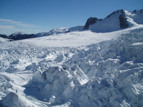
It’s Monday morning March 16th, and we have just returned from a helicopter ride over Fox Glacier and Mount Cook. It was my first time in a helicopter which as my pilot friend Ben Prewitt says “beats the air into submission rather than flying through it”. We lifted off from a small pasture field near town and quickly rose into the mountains. We flew around the face of Mt. Cook, the highest mountain in New Zealand a little over 12,000 feet and the peak which Sir Edmund Hilary used as his practice for the Mt. Everest ascent. I do not have the words to describe what we just saw. The mountains from that vantage point high in the air looked to be right below our feet but as we noticed when we saw some mountaineer’s huts on the side of the mountain, we were still not as close as we thought. It only served to enhance our image of the enormity of the mountain. The glacier, Fox Glacier, is a river of ice several hundred feet thick coming down a mountain pass. One can see that at some point in the not too distant past it was much, much larger. The surface of the glacier in some parts is folded almost like images one has seen of the surface of the brain. There are ripples in the ice that would easily swallow a person whole and these go on for miles. We landed on a smaller glacier higher up in the valley. Brenda threw a snowball down my shirt but on closer examination it’s not really “snow” but tiny discernable crystals of ice. The sun is bright up that high on top of the mountain and even though it is obviously cold enough to keep all of this snow and ice in place the brightness of the sun makes it feel quite pleasantly warm for the short time we’re up there..
The helicopter lifted off again and took us on a close up view of Mt. Cook and what seems like a near brush with the surface. We flew on down the valley over Fox again and this time the pilot banked sharply and made a couple of circles over the surface. I snapped pictures almost at random because I didn’t want to be looking through a camera view finder instead of seeing the sight first hand. I’ll have to down load them and see what it is I’ve got.
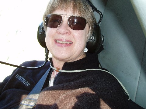
Brenda on her first helicopter ride
When the helicopter landed both of us had extreme pressure in our ears from the elevation changes but neither of us really cared at the moment. We were running on high adrenalin and shear amazement at what we had just seen. We were jabbering like school kids as we got back in the van for the short five minute drive back to our room. We downloaded the pictures immediately to the computer because we had snapped so quickly while we were up there we weren’t really sure what we had. Like all photographs of major natural features, these don’t do it justice but at least it will be a memory for us.
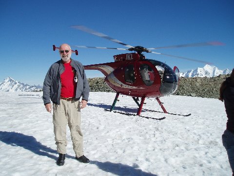
(From the look of this photo, I may have flown up to the glacier myself with the wings sprouting from my head. Never let a wife with a sense of humor take photos of you !)
Unable to match that experience with anything else we saddled up and rode the bike over to Franz Joseph, for lunch at the Blue Ice Restaurant which had been recommended to us. The 18 mile trip across the mountain to the glacier town of Fauns Joseph is, like all mountain roads in this country, beautiful. It was a construction zone which had us in mud for a few 100 yards other then that it was just standard issue beauty. The town is small , about the same size as Fox Glacier but looking a bit more polished. We walked the length of it and back again in about 10 minutes after lunch.
Along the sidewalk we found nearly a dozen Ducatis of various sorts parked in front of a restaurant with lots of leather-clad folks at the outside tables. Calling upon my keen powers of observation and deduction, I decided this must be a Ducati owners club or one heck of a coincidence. It was in fact the former and we met two of them again later when they passed us on a blind curve going over the mountain.
Back over the mountain again to Fox Glacier village (it is interesting how the same road can look so different when ridden from the other direction) we rode on to the access roads to walk up to the terminal face of the Glacier. The access road is really a dirt track through the woods leading up to the morraine area where the glacier has receded. There are signs along the way showing where the river of ice has been at various points in history. In 1935, when my father was 30, the glacier’s face was about two miles further down the mountain and far wider in the valley than it is now. It had been about a mile further down than that in 1750, so the recession had taken nearly 200 years to make the first mile and then (with the carbon dioxide producing industrial revolution in full swing) less than 100 for twice as much loss.
We parked the bike in the gravel lot constructed on one side of the large flat plain of gravel that had once been house-sized rocks much farther up the valley. From there a narrow path has been made through the morraine up to within a few hundred yards of the face. Even from that distance the ice monolith is impossibly huge, unimaginable without some form of context. I wish I had more knowledge of geology and could identify the variety of rocks which lay jumbled in the morraine. Some were so red, streaked with white, that they looked like large hunks of fresh-cut marbled beef. Others were grey, flat and almost limestone-like, as if somehow this glacier imported some rock from Central Kentucky. Some were streaked with what I assume is pyrite, “fools gold” glittering brightly in the late afternoon sun. Seeing the rock piles at the edges of the glacier and realizing it’s history of recession and advance (over the course of at least 5 different ice ages) it makes one realize that to understand its forces, one must think if four dimensions with time being just as important to the process as weight and speed.
When we came back to the highway from the first access road we doubled back and went up the second one just to see what a different view it might offer.. This one was a narrow dark path tunneling through overarching vegetation (more spooky looking ferns and trees from the scenery in “Jurassic Park” and “Lord of the Rings” terminating in a gravel parking lot at the top of the hill. The “glacier view” was down a long path through more jungle complete with sand flies. As we went down the steep path we realized that it was going to end on the other side of the parking area,, not any where near the glacier so we turned around and went back.
We had intended to do two more walks in the woods, but by the time we got back to the room supper time was approaching and our energy was flagging. We changed back into our street clothes and walked around the small town for a bit before settling on the Fox Glacier Hotel as a place to eat. The interior of the dining area is furnished in rather odd old- wood tables and chairs, all the similar theme but none matching. The salmon was excellent ,however, the beer quite acceptable and an old Bruce Springsteen album playing on the sound system, so all was well.
We walked back to our room and boxed some things that we had been using and mailed them back to the states at the local post office. Our bags should be about 11 pounds lighter but since both of us have each gained about that much so far on the trip and may not make much difference.
We left Fox Glacier on the morning of March 17th, headed north toward the Tasman coast. The weather was looking cloudy again and the reports were ominous of a front moving in from Australia. The sunshine held for a while, though, long enough for us to make it through the mountains down to the Tasman Sea. We called a halt early in the day when we reached Hokatika which seemed to be the last town promising any lodging and meal service for quite some distance up the coast.
We located the “i” center in town and were directed to the Heritage Highway motel nearby. Our room was spacious, had a galley kitchen and “spa” bath, all cheaper than the phone-booth sized accommodation we’d had the night before. Brenda decided to go explore the town while I went to explore Arthur’s Pass, a legendary ride I’d had on my “must do” list.